


ANDRICOS H60 RTK GNSS Receiver — 1408-Channel Survey & Agricultural Mapping Terminal with 4G CORS, WiFi, Bluetooth, 3.2in Screen, 5000mAh Battery & Centimetre-Level Accuracy
ANDRICOS H60 RTK GNSS Receiver — 1408-Channel Survey & Agricultural Mapping Terminal with 4G CORS, WiFi, Bluetooth, 3.2in Screen, 5000mAh Battery & Centimetre-Level Accuracy
Description
Description
The ANDRICOS H60 RTK GNSS Receiver is a specialist positioning and field-measurement terminal designed for agricultural surveying, outdoor navigation, land measurement, field mapping, construction layout support, environmental recording, GIS workflows, and technical positioning tasks.
The supplier lists 1408 channels, multi-constellation GNSS tracking, 4G CORS support, WiFi, Bluetooth, coordinate-system support, a 3.2-inch screen, 5000mAh lithium battery, Type-C interface, sensor support, internal storage, TF card expansion, and RTK accuracy of 0.8cm + 1ppm horizontal and 1.5cm + 1ppm vertical.
This product should remain in draft status until ANDRICOS verifies the exact manufacturer, package contents, base-and-rover configuration, RTK correction workflow, CORS/NTRIP support, software compatibility, regional 4G bands, certification documents, warranty, training/support availability, and after-sales process.
This product is not positioned as a casual GPS device, consumer navigation tool, aviation navigation device, vehicle safety system, autonomous-control product, or guaranteed centimetre-level survey solution unless the full selected configuration and operating conditions support those claims.
Product features
Product features
• H60 RTK GNSS receiver listed by supplier
• 1408 channels listed by supplier
• RTK accuracy listed by supplier: 0.8cm + 1ppm horizontal, 1.5cm + 1ppm vertical
• Multi-constellation GNSS support
• GPS, BDS, GLONASS, Galileo, QZSS, NavIC, and SBAS support listed by supplier
• 4G, CORS, WiFi, and Bluetooth support listed by supplier
• 5000mAh lithium battery listed by supplier
• Battery life listed by supplier: up to 12 hours at minimum backlight
• 3.2-inch screen
• 240 × 320 screen resolution listed by supplier
• Linux Qt operating system listed by supplier
• Type-C interface
• USB drive and virtual serial port support listed by supplier
• 3-axis electronic compass listed by supplier
• Accelerometer, barometer, and thermometer listed by supplier
• Multiple coordinate systems supported
• Custom coordinate formats supported
• Track, route, and waypoint recording listed by supplier
• Measurement functions for enclosed area, point-based area, curve length, straight-line distance, and terrain elevation difference analysis
• IP65 protection class listed by supplier
• Suitable for agricultural surveying, field mapping, outdoor navigation, land measurement, GIS workflows, and technical site recording
Important verification note:
The supplier listing contains inconsistencies, including “Brand Name: None,” “Dimensions: Tractors,” “Weight: tools,” and instructions to contact the supplier before ordering for correct pricing. ANDRICOS should verify the actual brand, model identity, quantity included, package contents, training support, warranty, certification paperwork, and return conditions before publishing.
Important base-and-rover note:
The title refers to an RTK GPS GNSS base and rover set, but the detailed specifications appear to describe a compact handheld RTK terminal. Do not advertise this as a full base-and-rover package unless the supplier confirms that both base and rover units are included.
Important RTK accuracy note:
RTK accuracy depends on correction source, CORS/NTRIP availability, mobile network coverage, satellite visibility, antenna setup, terrain, multipath interference, firmware, software configuration, coordinate system settings, and operator setup. Centimetre-level accuracy should not be treated as guaranteed in every environment.
Important compliance note:
This product includes wireless communication functions listed by the supplier, including 4G, WiFi, and Bluetooth. ANDRICOS should verify radio-equipment conformity, CE/UKCA documentation, regional mobile network compatibility, English safety instructions, and supplier compliance documents before sale.
Materials and care
Materials and care
Materials:
• ABS housing listed by supplier
• GNSS receiver electronics
• 4G, WiFi, and Bluetooth communication module
• 3.2-inch screen
• 5000mAh lithium battery
• Type-C interface
• Internal storage
• TF card slot
• Electronic compass
• Accelerometer
• Barometer
• Thermometer
• Internal positioning and measurement electronics
Care instructions:
• Read the full technical manual before field deployment.
• Confirm correction source, coordinate system, map settings, and network configuration before use.
• Fully charge before fieldwork.
• Use in open-sky conditions where possible for better GNSS performance.
• Keep ports, buttons, seals, and charging contacts clean and dry.
• Do not expose to deep water, heavy impact, crushing, open flame, or chemical contamination.
• Do not rely on the receiver as the sole safety system for vehicles, machinery, drones, or autonomous equipment.
• Back up measurement and waypoint data regularly.
• Store in a dry protective case when not in use.
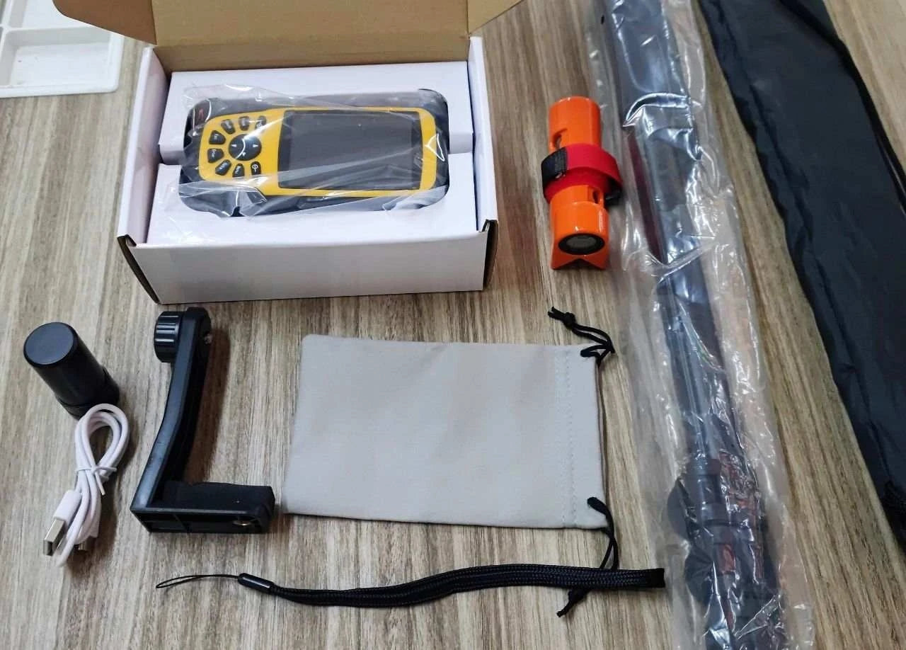
Shipping and returns
Shipping and returns
This product may be fulfilled through an international supply partner. Delivery times may vary depending on stock availability, selected configuration, customs processing, destination, training arrangement, and courier route.
If your order contains multiple items, they may arrive separately.
Returns are handled in line with the ANDRICOS Returns Policy. High-value GNSS products should be returned unused, undamaged, unmodified, unregistered where applicable, and with all original receivers, chargers, cables, manuals, serial labels, accessories, packaging, and documentation.
For faulty, damaged, incorrect, or missing items, contact ANDRICOS support with your order number, selected configuration, serial numbers where available, photos, and a clear description of the issue.
Technical Specifications
Technical Specifications
• Product type: RTK GNSS receiver / agricultural and survey positioning terminal
• Product name listed by supplier: H60 RTK
• Brand listed by supplier: None
• Type listed by supplier: RTK Receiver
• Channels: 1408
• RTK horizontal accuracy listed by supplier: 0.8cm + 1ppm
• RTK vertical accuracy listed by supplier: 1.5cm + 1ppm
• Time accuracy listed by supplier: 20ns
• Velocity measurement accuracy listed by supplier: 0.03m/s
• Cold start listed by supplier: Under 12 seconds
• Initialization time listed by supplier: Under 5 seconds typical
• Initialization reliability listed by supplier: Over 99.9%
• Data format listed by supplier: NMEA 0183, Unicore
• GPS signals listed by supplier: L1C/A, L1C, L2P(Y), L2C, L5
• BDS signals listed by supplier: B1I, B2I, B3I, B1C, B2a, B2b
• GLONASS signals listed by supplier: G1, G2, G3
• Galileo signals listed by supplier: E1, E5a, E5b, E6
• QZSS signals listed by supplier: L1C/A, L1C, L2C, L5
• NavIC signal listed by supplier: L5
• SBAS signal listed by supplier: L1C/A
• Network module: WiFi, Bluetooth, 4G
• Built-in functions listed by supplier: 4G, CORS, barometric temperature sensor, 3-axis electronic compass
• Operating system listed by supplier: Linux Qt
• Screen size: 3.2 inches
• Screen resolution: 240 × 320
• Housing material: ABS
• Battery: 5000mAh lithium battery
• Battery life: 12 hours at minimum backlight listed by supplier
• Interface: Type-C, charging, USB drive, virtual serial port
• Protection class: IP65
• Size listed by supplier: 70 × 143 × 36mm
• Weight listed by supplier: 251g
• TF card support: Up to 128GB, FAT32
• Internal storage: Up to 64GB, customisable
• Bluetooth: Dual-mode Bluetooth 5.0, BR/EDR, BLE
• 4G: CAT1, region-dependent versions listed by supplier
• Coordinate systems listed by supplier: WGS84, CGCS2000, Xi’an 80, Beijing 54, UTM, MGRS, and user-defined systems
• Data recording listed by supplier: 10,000 track points per track, 1,000 waypoints per route, 3,000 points per waypoint file
• Operating temperature listed by supplier: -20°C to 70°C
• Storage temperature listed by supplier: -20°C to 70°C
• Humidity: 95% non-condensing listed by supplier
• Vibration / shock listed by supplier: GJB150.16A-2009 / MIL-STD-810F
• Language support listed by supplier: Chinese, English, Korean, Spanish, and customisable options
• Origin listed by supplier: Guangdong, China / Mainland China
Couldn't load pickup availability
Text
Share


Compact RTK positioning for agricultural and field measurement workflows.
A compact RTK GNSS receiver listed for agricultural surveying, outdoor navigation, land measurement, field mapping, and technical positioning tasks. Selected by ANDRICOS for review as an economical RTK option for users who need more capable positioning than standard handheld GPS.
With supplier-listed 1408-channel GNSS tracking, CORS/4G support, WiFi, Bluetooth, centimetre-level RTK accuracy, 3.2-inch screen, 5000mAh battery, coordinate-system support, and measurement functions, the H60 RTK could become a useful specialist product if the package contents and compliance documents are verified.