


ANDRICOS E1 RTK GNSS Receiver Set — 1408-Channel Base & Rover Survey System with 60° IMU Tilt, IP68 Housing, Multi-Constellation GNSS & Internal Radio
ANDRICOS E1 RTK GNSS Receiver Set — 1408-Channel Base & Rover Survey System with 60° IMU Tilt, IP68 Housing, Multi-Constellation GNSS & Internal Radio
Description
Description
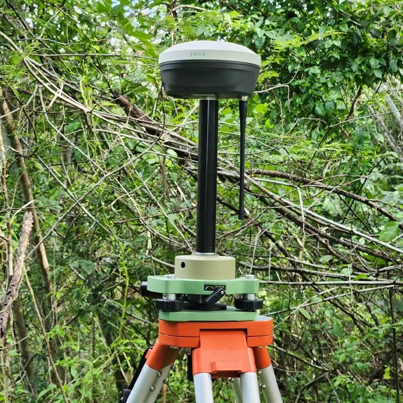
The ANDRICOS E1 RTK GNSS Receiver Set is a specialist base-and-rover positioning system designed for land surveying, mapping, construction layout, GIS data collection, field measurement workflows, and professional RTK positioning projects.
The supplier lists 1408 channels, multi-constellation satellite tracking, 60° IMU tilt adjustment, IP68-rated housing, WiFi, Bluetooth, internal radio mode, 8GB storage, and support for GPS, GLONASS, Galileo, BDS, QZSS, IRNSS/NavIC, and SBAS signals.
This product should be treated as a high-ticket technical survey instrument. ANDRICOS should verify the exact manufacturer, model identity, included hardware, base-and-rover configuration, controller/software compatibility, correction workflow, radio legality, warranty, CE/UKCA documentation, and after-sales support before publishing.
This product is not positioned as a casual GPS device, consumer navigation tool, drone-autopilot safety system, aviation device, or guaranteed centimetre-level survey solution unless full documentation confirms the claim for the selected configuration.
Product features
Product features
• E1 RTK GNSS receiver set
• Base and rover workflow listed by supplier
• 1408 channels listed by supplier
• 60° IMU tilt adjustment listed by supplier
• Multi-constellation GNSS tracking
• GPS, GLONASS, Galileo, BDS, QZSS, IRNSS/NavIC, and SBAS support listed by supplier
• IP68 rating listed by supplier
• Internal radio mode listed by supplier
• Measurement range listed by supplier: 5km in internal radio mode
• WiFi and Bluetooth network module listed by supplier
• 8GB storage listed by supplier
• Magnesium-aluminium alloy housing listed by supplier
• RTK initialization time listed by supplier: under 5 seconds typical
• Re-acquisition time listed by supplier: under 1 second
• Optional speaker for real-time status voice broadcast listed by supplier
• Suitable for surveying, mapping, construction layout, land measurement, GIS workflows, and field positioning tasks
Important verification note:
The supplier listing includes inconsistent or incomplete details, including “Brand Name: None,” “Electronic: No,” “Contact customer service for pricing,” and references to multiple signal tables and product naming. ANDRICOS should verify the exact product model, brand, package contents, controller compatibility, radio frequency, supported software, warranty, certification documents, and return conditions before selling.
Important RTK accuracy note:
RTK performance depends on correction source, base-rover distance, satellite visibility, antenna setup, IMU calibration, terrain, radio or network connection, multipath interference, firmware, software configuration, and operator setup. Centimetre-level accuracy should not be treated as guaranteed in every environment.
Important radio compliance note:
The supplier lists internal radio functionality. Customers are responsible for using radio functions only where legally permitted. ANDRICOS should verify radio frequency, transmission power, conformity documents, and UK/EU market compliance before listing or advertising radio performance.
Materials and care
Materials and care
Materials:
• Magnesium-aluminium alloy housing listed by supplier
• GNSS receiver electronics
• Internal storage
• Internal radio components where supplied
• WiFi and Bluetooth module
• GNSS antenna system
• IMU tilt components
• Charging and data interfaces
• Optional speaker where supplied
Care instructions:
• Read the full technical documentation before field deployment.
• Confirm base, rover, controller, software, and correction settings before use.
• Charge and test the receiver before site work.
• Keep connectors, antenna points, seals, and charging contacts clean and dry.
• Calibrate IMU tilt functions according to the supplier instructions.
• Avoid dropping, crushing, opening, or modifying the receiver.
• Do not use near strong RF interference without checking signal performance.
• Do not rely on the receiver as the sole safety system for machinery, vehicles, drones, or autonomous equipment.
• Store in a dry protective case when not in use.
• Back up survey data regularly.
Shipping and returns
Shipping and returns
This product may be fulfilled through an international supply partner. Delivery times may vary depending on stock availability, selected configuration, customs processing, destination, and courier route.
If your order contains multiple items, they may arrive separately.
Returns are handled in line with the ANDRICOS Returns Policy. High-value GNSS products should be returned unused, undamaged, unmodified, unregistered where applicable, and with all original receivers, antennas, chargers, cables, mounts, cases, manuals, serial labels, and packaging.
For faulty, damaged, incorrect, or missing items, contact ANDRICOS support with your order number, selected configuration, serial numbers where available, photos, and a clear description of the issue.
Technical Specifications
Technical Specifications
• Product type: RTK GNSS receiver / base and rover survey system
• Product name listed by supplier: E1 GNSS Receiver
• Brand listed by supplier: None
• Type listed by supplier: RTK Receiver
• Channels: 1408
• IP rating: IP68
• IMU tilt adjustment listed by supplier: 60°
• Measurement range listed by supplier: 5km in internal radio mode
• Network module: WiFi, Bluetooth
• Storage: 8GB listed by supplier
• Expandable storage note: Up to 32GB according to user demand listed by supplier
• Housing material: Magnesium-aluminium alloy
• Size: Φ133.5mm × 67mm
• Weight: 870g
• Operating temperature: -30°C to 65°C
• Certification listed by supplier: CE
• Satellite systems listed by supplier: GPS, GLONASS, Galileo, BDS, QZSS, IRNSS/NavIC, SBAS
• GPS signals listed by supplier: L1 C/A, L1C, L2P, L2C, L5
• GLONASS signals listed by supplier: G1, G2, G3
• Galileo signals listed by supplier: E1, E5a, E5b
• BDS signals listed by supplier: B1I, B2I, B3I, B1C, B2a, B2b
• QZSS signals listed by supplier: L1, L2, L5
• IRNSS/NavIC signal listed by supplier: L5
• SBAS listed by supplier: WAAS, EGNOS, SDCM, BDSBAS, GAGAN
• L-Band: Upgradeable listed by supplier
• Cold start: Under 30 seconds listed by supplier
• RTK initialization time: Under 5 seconds typical listed by supplier
• RTK initialization reliability: Over 99.9% listed by supplier
• Re-acquisition: Under 1 second listed by supplier
• Place of origin listed by supplier: Shanghai, China
• Origin listed by supplier: Mainland China
• High-concerned chemical: None listed by supplier
无法加载取货服务可用情况
Text
Share


High-channel RTK positioning for serious survey and mapping workflows.
A specialist 1408-channel RTK GNSS receiver set designed for survey support, mapping, GIS data collection, construction layout, and advanced field positioning workflows. Selected by ANDRICOS for technical users who need base-and-rover capability rather than consumer GPS navigation.
With supplier-listed multi-constellation GNSS tracking, 60° IMU tilt adjustment, IP68 housing, internal radio mode, WiFi, Bluetooth, 8GB storage, and base-rover survey support, the E1 receiver set is a high-ticket technical product that should be sold only after compatibility and certification checks are complete.