


ANDRICOS Sino T10 PLUS RTK GNSS Receiver — 1590-Channel IMU Land Survey System with Base & Rover Support, IP67 Housing, 4G, WiFi, Bluetooth & High-Precision Mapping Workflow
ANDRICOS Sino T10 PLUS RTK GNSS Receiver — 1590-Channel IMU Land Survey System with Base & Rover Support, IP67 Housing, 4G, WiFi, Bluetooth & High-Precision Mapping Workflow
Description
Description
Selected by ANDRICOS. Brand listed by supplier: Sino.
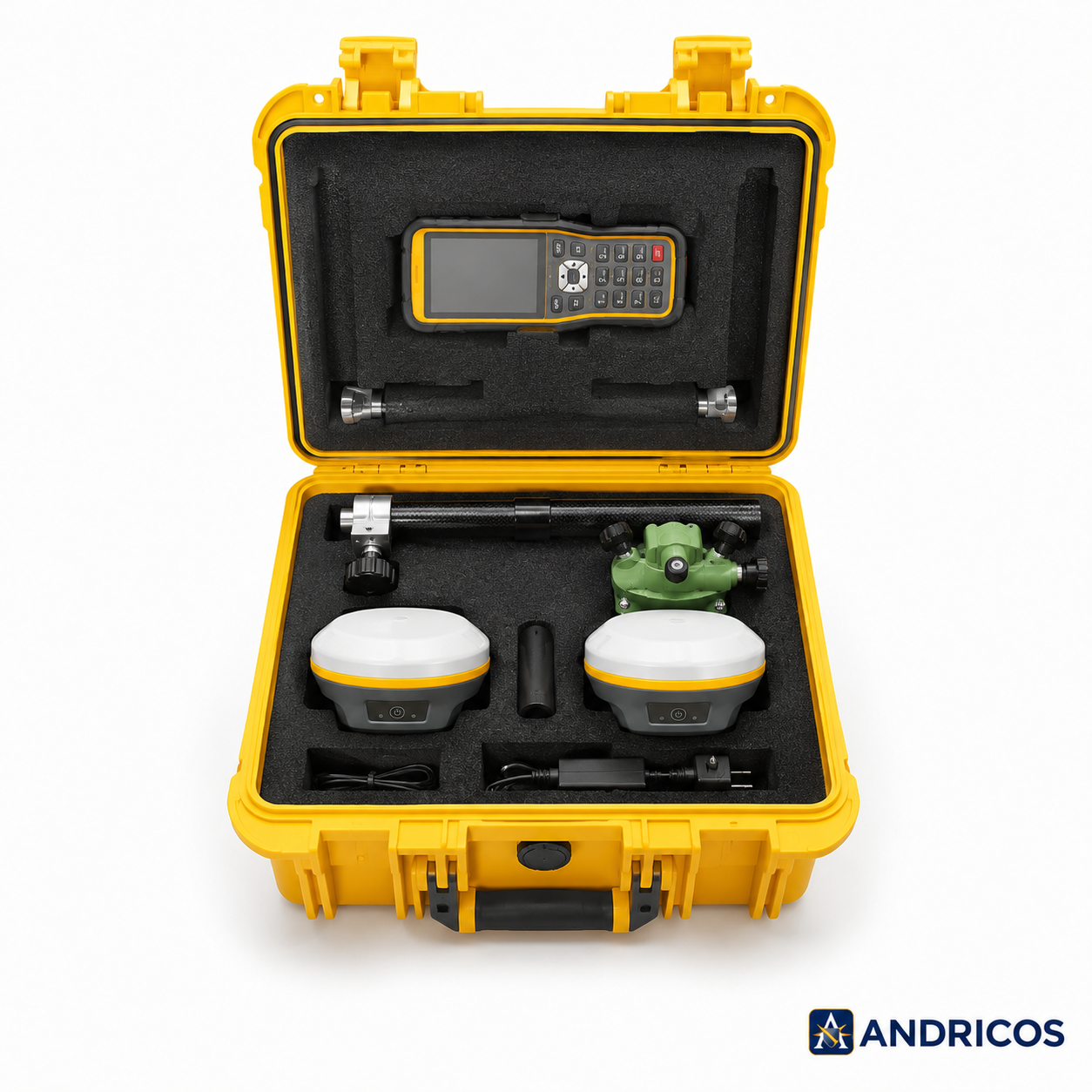
The ANDRICOS Sino T10 PLUS RTK GNSS Receiver is a high-ticket land-survey and mapping receiver designed for professional RTK positioning workflows, base-and-rover survey setups, construction layout, GIS data collection, field mapping, land measurement, and technical site documentation.
The supplier lists 1590 parallel channels, multi-constellation GNSS tracking, IMU support, IP67-rated housing, 4G, WiFi, Bluetooth, magnesium-aluminium alloy construction, fast signal recapture, and more than 30 hours of working time in mobile network mode.
This product should be treated as a specialist survey instrument, not a casual GPS device. ANDRICOS should verify the exact package contents, controller/software compatibility, RTK accuracy documentation, base-and-rover configuration, correction workflow, regional network compatibility, certification paperwork, warranty terms, and after-sales support before publishing.
This product is not positioned as a guaranteed centimetre-level survey solution, aviation navigation device, vehicle safety system, drone-autopilot safety device, or autonomous machinery control system unless full manufacturer documentation confirms those uses.
Product features
Product features
• Sino T10 PLUS RTK GNSS receiver
• Base and rover survey workflow listed by supplier
• 1590 parallel channels listed by supplier
• IMU support listed by supplier
• Multi-constellation GNSS support
• GPS, BDS, GLONASS, Galileo, QZSS, NavIC, and SBAS support listed by supplier
• 4G, WiFi, and Bluetooth network module listed by supplier
• IP67 rating listed by supplier
• Signal recapture time listed by supplier: 1 second
• RTK initialization time listed by supplier: under 5 seconds for baseline distance under 10km
• Working time listed by supplier: over 30 hours in mobile network mode
• Magnesium-aluminium alloy shell listed by supplier
• Drop resistance listed by supplier: resistant to 2m cement-floor drop
• Operating temperature listed by supplier: -30°C to 65°C
• Suitable for land surveying, mapping, construction layout, GIS workflows, field measurement, and site documentation
Important verification note:
The supplier listing includes strong professional survey claims. Before listing this product live, verify the manufacturer documentation, included receiver quantity, controller inclusion, antenna setup, charging equipment, software compatibility, RTK correction methods, supported data formats, warranty process, serial identification, certification paperwork, and after-sales technical support.
Important RTK accuracy note:
RTK performance depends on correction source, base-rover distance, satellite visibility, antenna setup, IMU calibration, mobile network or radio connection, terrain, multipath interference, firmware, software configuration, and operator setup. Centimetre-level results should not be treated as guaranteed in every field environment.
Important compliance note:
This product includes wireless communication functions listed by the supplier, including 4G, WiFi, and Bluetooth. ANDRICOS should verify CE/UKCA conformity, radio-equipment documentation, regional network compatibility, safety information, and English instructions before sale.
Materials and care
Materials and care
Materials:
• Magnesium-aluminium alloy shell listed by supplier
• GNSS receiver electronics
• IMU positioning components
• 4G, WiFi, and Bluetooth communication module
• GNSS antenna system
• Battery system
• Charging and data interfaces
• Internal survey receiver hardware
Care instructions:
• Read the full technical manual before field deployment.
• Confirm controller, software, correction source, and base-rover setup before use.
• Charge fully before survey work.
• Keep connectors, seals, antenna points, and charging contacts clean and dry.
• Calibrate IMU functions according to manufacturer instructions.
• Avoid dropping, crushing, opening, modifying, or exposing the receiver to unnecessary shock.
• Do not use near strong RF interference without checking signal quality.
• Do not rely on the receiver as the sole safety system for vehicles, drones, machinery, or autonomous equipment.
• Store in a dry protective case when not in use.
• Back up survey and mapping data regularly.
Shipping and returns
Shipping and returns
This product may be fulfilled through an international supply partner. Delivery times may vary depending on stock availability, selected configuration, customs processing, destination, and courier route.
If your order contains multiple items, they may arrive separately.
Returns are handled in line with the ANDRICOS Returns Policy. High-value GNSS products should be returned unused, undamaged, unmodified, unregistered where applicable, and with all original receivers, antennas, chargers, cables, mounts, cases, manuals, serial labels, accessories, and packaging.
For faulty, damaged, incorrect, or missing items, contact ANDRICOS support with your order number, selected configuration, serial numbers where available, photos, and a clear description of the issue.
Technical Specifications
Technical Specifications
• Product type: RTK GNSS receiver / land surveying system
• Product name listed by supplier: Sino T10 PLUS
• Brand listed by supplier: Sino
• Type listed by supplier: RTK Receiver
• Electronic: Yes
• Parallel channels: 1590
• Network module: 4G, WiFi, Bluetooth
• IP rating: IP67
• IP grade: IP67
• Operating temperature: -30°C to 65°C
• Working time: Over 30 hours in mobile network mode listed by supplier
• Signal recapture: 1 second listed by supplier
• RTK initialization time: Under 5 seconds for baseline distance under 10km listed by supplier
• Size: 130 × 130 × 65.5mm
• Weight: 790g
• Drop resistance: Resistant to 2m cement-floor drop listed by supplier
• GPS signals listed by supplier: L1C, L1C/A, L2C, L5, L2P(Y)
• BDS signals listed by supplier: B1L, B2L, B3L, B1C, B2A, B2B
• GLONASS signals listed by supplier: G1C, G1P, G2C, G2P, G3
• Galileo signals listed by supplier: E1, E5A, E5B, E6, AltBOC
• QZSS signals listed by supplier: L1C/A, L1C, L2C, L2S, L5, L5s, L6
• NavIC signal listed by supplier: L5
• SBAS signals listed by supplier: L1C/A, L5C
• Place of origin listed by supplier: Guangdong, China
• Origin listed by supplier: Mainland China
• High-concerned chemical: None listed by supplier
No se pudo cargar la disponibilidad de retiro
Text
Share


Professional RTK positioning for survey, mapping, and site workflows.
A specialist RTK GNSS receiver designed for land surveying, mapping, construction layout, GIS data collection, field measurement, and advanced site documentation. Selected by ANDRICOS for technical users who need a serious GNSS receiver platform rather than consumer navigation hardware.
With supplier-listed 1590-channel tracking, IMU support, IP67 housing, 4G, WiFi, Bluetooth, multi-constellation GNSS, fast signal recapture, and long mobile-network working time, the Sino T10 PLUS sits in the high-ticket survey equipment category and should be sold only after full verification.