


ANDRICOS Laser RTK GNSS Receiver — Multi-Frequency Dual Camera GIS Mapping Receiver with IP68 Rating, Tilt Correction, 4G/WiFi/Bluetooth & Centimetre-Level Positioning
ANDRICOS Laser RTK GNSS Receiver — Multi-Frequency Dual Camera GIS Mapping Receiver with IP68 Rating, Tilt Correction, 4G/WiFi/Bluetooth & Centimetre-Level Positioning
Description
Description
Selected by ANDRICOS. Supplier listing references Hi Target G9L / V5-style GNSS RTK equipment, but the brand field is listed as none. Customers should confirm the exact model, package contents, software compatibility, and support requirements before purchase.
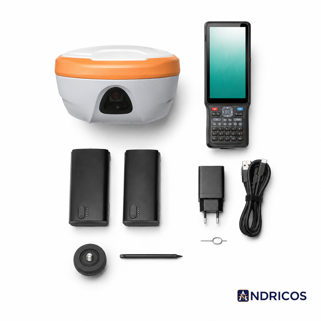
The ANDRICOS Laser RTK GNSS Receiver is a specialist multi-frequency GNSS positioning device designed for field surveying, GIS data collection, mapping, construction layout support, geospatial workflows, and technical positioning tasks.
Built around a GNSS RTK receiver format, the supplier lists multi-constellation satellite support, dual camera / laser-assisted functionality, IP68 protection, Bluetooth, WiFi, 4G connectivity, tilt correction within 60°, and centimetre-level RTK accuracy under suitable conditions.
This is not a consumer GPS device, basic navigation tool, or casual outdoor accessory. It is a specialist field-surveying instrument intended for users who understand GNSS, RTK correction workflows, GIS data collection, field controllers, satellite visibility, and survey setup.
Product features
Product features
Product features:
• Multi-frequency GNSS RTK receiver
• Supplier-listed dual camera / laser GNSS RTK configuration
• Designed for GIS data collection, surveying, mapping, and field positioning
• Multi-constellation satellite support listed by supplier
• GPS, BDS, GLONASS, Galileo, QZSS, SBAS, and NavIC signal support listed by supplier
• RTK accuracy listed by supplier: 8mm + 0.5ppm horizontal, 15mm + 0.5ppm vertical
• Tilt correction within 60° listed by supplier
• Tilt correction accuracy listed as under 2cm
• IP68 rating listed by supplier
• Bluetooth, WiFi, and 4G network module listed by supplier
• 7.4V 6500mAh battery listed by supplier
• Operating temperature listed by supplier: -30°C to 65°C
• Compact receiver weight listed as 0.78kg, receiver only
• Laser camera sensor size listed as 1/3.06"
• Suitable for advanced surveying, mapping, GIS, geospatial, construction layout, and field data workflows
Important RTK performance note:
Supplier-listed centimetre-level accuracy depends on correct field setup, satellite visibility, correction data, baseline length, receiver configuration, firmware, controller/software compatibility, antenna setup, environmental obstruction, interference, and operator workflow. Accuracy is not guaranteed in all environments.
Materials and care
Materials and care
Materials:
• Electronic GNSS receiver body
• Internal GNSS receiver and antenna components
• Laser/camera module listed by supplier
• Internal communication hardware
• 4G, WiFi, and Bluetooth network module listed by supplier
• 7.4V 6500mAh battery system
• IP68-rated housing listed by supplier
Care instructions:
• Read all manufacturer instructions before first field use.
• Confirm exact model, firmware, software, and controller compatibility before deployment.
• Fully charge the battery before survey work.
• Confirm RTK correction status before recording important measurements.
• Check satellite visibility, baseline, tilt compensation, and data collection settings before use.
• Keep ports, seals, casing, lens areas, and connectors clean and free from mud, grit, and moisture.
• Avoid dropping, crushing, or exposing the receiver to heavy impact.
• Dry the unit fully before storage after wet field conditions.
• Back up survey and GIS data regularly.
• Store in a protective case when not in use.
• Do not rely on the receiver for safety-critical positioning without professional verification and independent checks.
Shipping and returns
Shipping and returns
This product may be fulfilled through an international supply partner. Delivery times may vary depending on stock availability, selected package option, destination, customs processing, and courier route.
If your order contains multiple items, they may arrive separately.
Returns are handled in line with the ANDRICOS Returns Policy. Items should be returned unused, undamaged, and with original accessories, packaging, manuals, cables, chargers, cases, and protective components where possible.
For faulty, damaged, missing, or incorrect items, contact ANDRICOS support with your order number, photos, videos where useful, and a clear description of the issue.
Technical setup notice:
This is a specialist GNSS/RTK product. Customers should confirm compatibility with their intended correction service, controller, GIS software, survey workflow, data format, firmware, and field requirements before purchase.
Technical Specifications
Technical Specifications
• Product type: Multi-frequency GNSS RTK receiver
• Product name listed by supplier: Laser GNSS RTK
• Supplier title reference: Hi Target G9L / V5 surveying mapping equipment
• Brand listed by supplier: None
• Receiver type: Multi-frequency receiver
• GPS signals listed: L1C/A, L1C, L2P(Y), L5, L2C
• BDS signals listed: B3L, B2L, B2A, B1L, B1C, B2B
• GLONASS signals listed: L1, L2, L3
• Galileo signals listed: E5B, E1, E5A, E6
• QZSS signals listed: L5, L1, L2, L6
• SBAS signals listed: L1, L2, L5
• NavIC signal listed: L5
• RTK accuracy listed by supplier: horizontal 8mm + 0.5ppm; vertical 15mm + 0.5ppm
• Tilt correction: within 60°
• Tilt correction accuracy listed: under 2cm
• IP rating listed by supplier: IP68
• Network module: Bluetooth, WiFi, 4G
• Laser camera sensor size: 1/3.06"
• Battery: 7.4V 6500mAh
• Operating temperature: -30°C to 65°C
• Receiver weight: 0.78kg, receiver only
• Electronic: Yes
• DIY supplies category listed by supplier: Electrical
• Origin listed by supplier: Mainland China
• High-concerned chemical: None listed by supplier
No se pudo cargar la disponibilidad de retiro
Text
Share


Advanced RTK positioning for serious GIS and survey workflows.
A specialist GNSS RTK receiver designed for mapping, GIS data collection, field surveying, construction layout support, and technical geospatial workflows. Selected by ANDRICOS for advanced users who need a high-precision positioning tool beyond consumer GPS equipment.
With multi-constellation satellite support, supplier-listed centimetre-level RTK performance, IP68 protection, tilt correction, dual camera / laser-assisted functionality, and 4G, WiFi, and Bluetooth connectivity, this receiver is built for demanding field positioning tasks where setup and workflow control matter.